 |
|
|
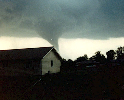 |
This photo (Left) was taken looking south from Herrin, IL as the F-4 tornado was about to dip down near the Williamson County Airport west of Interstate 57. This picture was posted on the National Weather Service web site. The time was about 3:10 pm on Saturday, May 29, 1982. The Tornado varied from F-2 to F-4 strength througout its entire 17 mile track in Williamson County. |
| This photo (right) is the Saturday, May 29, 1982 Marion, IL F-4 Tornado as it stalled above the Marion Ford-Mercury dealership on the South side of Illinois RT-13, churning it's winds on new and used cars alike. The building was totally demolished, along with hundreds of automobiles. For weeks following the tornado, residents of the SW side of Marion could hear the cars being hauled down Carbon Street, then to Wildcat Drive, then to the scrap yard south of Marion. There were 1,000 people without homes after the Tornado did it's dirty work! The total cost of the Tornado clean-up and rebuilding was about $98 million. | 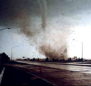 |
 On Saturday, May 29, 1982, a deadly F4 tornado carved a 17-mile long
path across Williamson County, Illinois, including the city of Marion.
At times, the tornado was nearly a quarter mile wide. The tornado
first touched down about 3 miles northwest of Carterville around 3:05 p.m.
After moving southeast across Carterville to Crainville, the twister then
paralleled Illinois Route 13 through Marion. On the ground for nearly
30 minutes, the tornado claimed 10 lives in Marion, injured nearly 200,
and left approximately 1,000 persons homeless across Williamson County.
On Saturday, May 29, 1982, a deadly F4 tornado carved a 17-mile long
path across Williamson County, Illinois, including the city of Marion.
At times, the tornado was nearly a quarter mile wide. The tornado
first touched down about 3 miles northwest of Carterville around 3:05 p.m.
After moving southeast across Carterville to Crainville, the twister then
paralleled Illinois Route 13 through Marion. On the ground for nearly
30 minutes, the tornado claimed 10 lives in Marion, injured nearly 200,
and left approximately 1,000 persons homeless across Williamson County.
What follows is the description of the tornado's path taken from the May 1982 issue of Storm Data, a monthly publication of the National Climatic Data Center in Asheville, North Carolina. "Ten persons were killed and 181 persons were injured when a massive tornado cut a path through 3 towns in Williamson County and contained 3 separate vorticies rotating around the main tornado. The initial touchdown was approximately 4 miles northwest of Carterville and 1 mile north of Crab Orchard Lake. It lifted briefly, touching down in a subdivision of Carterville demolishing 2 homes and causing damage to several others. The tornado again lifted briefly and touched down again in downtown Carterville. It traveled through the east section of town and through Crainville where several homes, business buildings and many trees were damaged. The tornado then increased in size and several funnels were observed within the tornado. Extensive damage occurred at the Williamson County Airport between 1410 and 1415 CST. Then the tornado either changed course or formed a new funnel as it followed highway 13 through Marion. A truck plaza near Interstate 57 in western Marion was demolished. A car was struck on Interstate 57 and exploded. A motel and 3 shopping centers were damaged. Two of the 39 motel occupants were injured. The Shawnee Village 190 unit apartment complex was destroyed and 2 schools were severely damaged. One person died when a wall fell and 2 more died when they were literally blown out of their homes. In Marion a total of 161 homes and 47 businesses were destroyed; 59 homes and 29 businesses suffered damage. In Williamson County, 52 businesses were destroyed and 37 were heavily damaged. In total, 648 homes were damaged with 40% of these destroyed and 23% suffering major damage. Many persons were trapped under rubble. Over 200 cars were damaged or destroyed. The tornado lifted approximately 1 mile east-southeast of Routes 166 and 13; and the estimated damage was between 85 to 100 million dollars. The total homeless was approximately 1,000." |